Disaster · Before and after
Derna, Libya (dam burst)
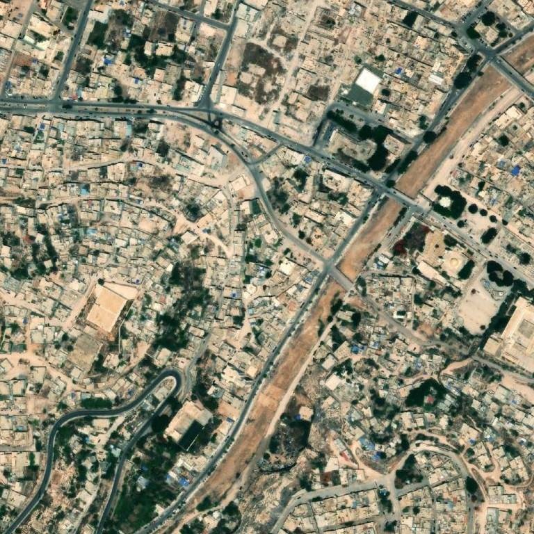
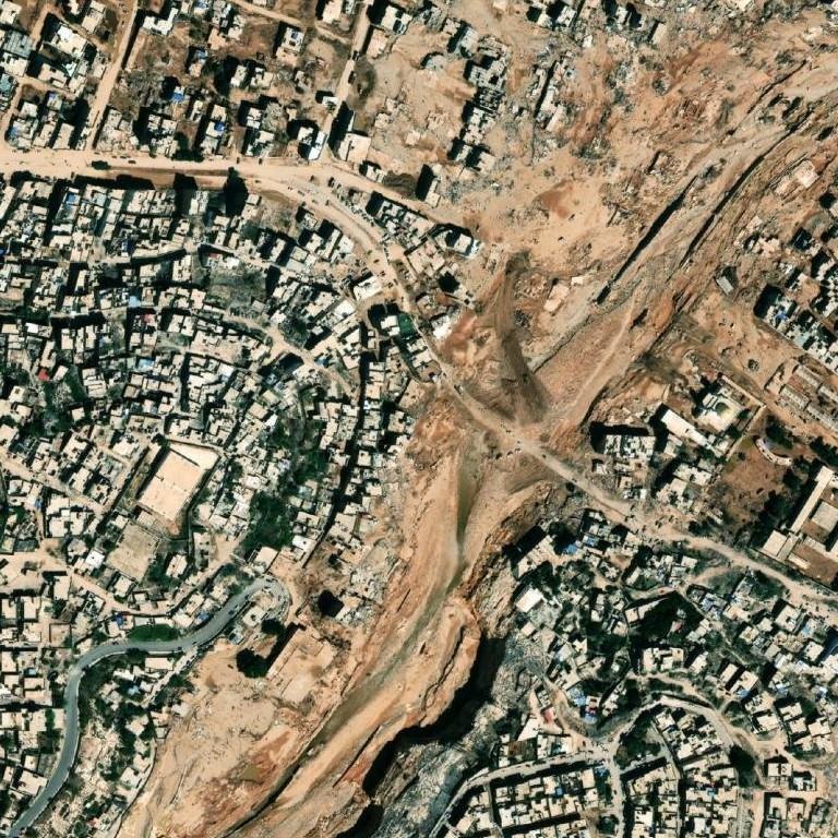
Two dated satellite photos of the same spot, 1 Jul 2023 and 15 Sep 2023. Open them in GeoWhisperer to swipe between them, check the pair and read what changed.
Open this comparisonCompare another place
What changed
Major change. Massive destruction is visible along the river channel running through the center and eastern parts of the area. Multiple city blocks of buildings have been completely removed and replaced by wide swaths of mud, silt, and scoured earth.
- Square A2high confidenceMultiple city blocks of buildings are missing and covered in mud and debrisBefore: Dense neighborhood with numerous multi-story buildings and paved streets After: Most buildings in the eastern and southern portions are missing, replaced by bare earth and silt deposits
- Square A3high confidenceEntire urban area destroyed and replaced by a wide scoured channelBefore: Dense residential blocks adjacent to a narrow dry channel After: All buildings are absent, replaced by a wide scoured path of mud, silt, and eroded ground
- Square B2high confidenceEastern section of buildings gone and covered in sedimentBefore: Dense buildings and street network extending toward the channel After: Eastern half of the cell is cleared of buildings and covered in brown silt and mud
- Square B3high confidenceWidespread destruction of buildings across almost the entire cellBefore: Urban structures, roads, and plazas surrounding the central wadi channel After: Almost all buildings are missing, replaced by a broad field of mud, silt, and scoured terrain
- Square C2high confidenceChannel significantly widened with adjacent buildings removed and banks erodedBefore: Narrow wadi channel with buildings built right along both banks After: Buildings along the channel are gone, leaving deeply eroded gulleys and thick mud deposits
The square is split into nine numbered squares, A1 to C3. The changes above sit in A2, A3, B2, B3, C2.
Differences that are not changes
Things that look different in the two photos but do not mean anything changed on the ground:
- Square A1: Buildings appear darker with harsher contrast. Not counted: shadow.
- Square C3: Apparent texturing difference on rooftops on the far right edge. Not counted: viewing angle.
The photos
| Place | Derna, Libya (dam burst) |
|---|---|
| Coordinates | 32.76160, 22.63940 |
| Before photo taken | 1 Jul 2023 · 0.46 m per pixel |
| After photo taken | 15 Sep 2023 · 0.31 m per pixel |
| Source | Esri World Imagery Wayback (Esri, Maxar and partners) |
| Category | Disaster |
The movie
GeoWhisperer turns this comparison into a short film with numbered markers: watch or download the MP4.
Check it yourself
- This spot on OpenStreetMap
- Sentinel Hub EO Browser, free satellite archive
- Every dated photo of this spot in the Esri archive
The reading above was produced by GeoWhisperer from these two photos and nothing else. It describes what is visible, never why it happened or who did it, and it can miss things or misread shadows, season and viewing angle. Check every line by eye with the slider in the tool. Another OSINT tool by Henk van Ess, www.digitaldigging.org.